 Live Music Archive
 Librivox Free Audio
 Metropolitan Museum
 Cleveland Museum of Art
 Internet Arcade
 Console Living Room
 Books to Borrow
 Open Library
 TV News
 Understanding 9/11
tv CNN Newsroom CNN October 29, 2012 6:00am-8:00am PDT
6:00 am

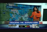
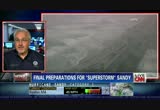
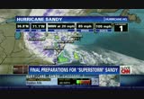
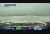
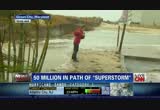
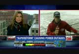
you can see the trees. hurricane irene they lost enough trees. $22,000 worth of trees fell down. this storm expected to be much tougher, more devastating than hurricane irene. look at this. that's a scaffold around an art project. new york city is full of scaffolding like that. things that we are watching today. want to head it over now to "cnn newsroom." newsroom." they're up next. -- captions by vitac -- www.vitac.com good morning to you. i sure hope you're keeping dry somewhere. i'm carol costello. thank you so much for being with us. we begin this morning with hurricane sandy, within hours expected to explode into this superstorm. most of us have never season anything like it in our lifetime. already huge, tropical storm force winds spanning a width of nearly 1,000 mimes. it's aiming at the heart of the east coast, the most heavily populated corridor in the country. 50 million people are expected to feel the effects. hundreds of thousands are now
6:01 am
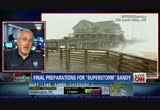
under evacuation orders. fema predicts damage costs of about $3 billion just for wind damage alone. heavy rains or snow, storm surges, widespread flooding across the region depending upon where you live. we're also following a drama unfolding out to sea. a rescue is under way for the crew of the hms bounty, the ship built for the hollywood movie "mutiny on bounty." unbelievable. we'll have more on that es cue in just a minute. let's begin with the first reports of power outages. they're already rolling in. see meteorologist rob marciano is in the iconic new jersey town of asbury park. high, ro hi, rob. can you hear me? >> reporter: i hear you carol. you're right about that. this is a special place. the heyday of the '20s this boardwalk would be bustling. convention center you've seen behind me as gone through a
6:02 am
number of boom and bust cycles and resuhr jenr and resuhr jeesurge jenss. the water is over the pylons, the pout -- relentless surf has been pounding this beach. right now we're almost at about high tide. you can see the foam coming up right up to the -- right up to the border here of the boardwalk. that alone is unheard of. the ocean should be 200 yards that way. so even with the storm being 250 miles from us, we're getting a surge of about three feet right now. matter of fact, just down the road in atlantic city, just up the road at sandy hook, they've already reached major coastal flooding storm surge stages. and what's going to happen tonight is about twice of what you're seeing right now. so in the next 12 hours, these seas will continue to build and
6:03 am
continue to churn and continue to pound away at this shoreline. obviously doing a tremendous amount of damage as far as beach erosion. but structural damage tonight. we'll just have to wait and see with what happens there. we've got winds now that are approaching tropical storm force. and that relentless wind that will increase over the next 12 hours. through the day, tomorrow afternoon and evening. coastal communities have been evacuated. here in this county alone there's about 600,000 people that live here. they've got a couple shelters open. but most people are sheltering in place or are up there with their friends and family. look at the foam. right up here. foam. all the locals are telling me they don't see that. last time they saw that, really 1992 which was the last epic nor'easter that came through here. at that point the water came up and over this boardwalk. we expect that to happen later on tonight. >> rob marciano, many thanks. i should explain where i am. i'm in washington, d.c., this morning where people are also getting ready for the big storm.
6:04 am

as you can see, pretty steady rain. we're expecting the rain to come down really hard around 11:00. we're expecting 40 to 50 mile per hour wind gusts. steady rain is supposed to last 36 hours. that will saturate the ground. a lot of big trees in the area that will probably topple over and fall on to electrical lines. that means massive power outages. i'll be in old town alexandria later this afternoon bringing updates from there. if you want to sense how seriously local officials are taking this, consider this. new jersey weather service issued this dire warning yesterday for anyone ignoring evacuation orders. if you are reluctant, think about the rescue recovery teams who will rescue you if you are injured or recover your remains if you do not survive. >> we expect today's tide, the
6:05 am

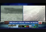
one at noon today could be in the area of the 1992 perfect storm backup in long island sound. that's going to be a big wake-up call for people if that happens as to what tonight can be, which is far worse. >> all right. we don't know if the crew of the hms bounty heeded the warnings. but we do know they are in big trouble this morning. they are in the water 90 miles off the coast of cape hatteras, north carolina. they're sitting in lifeboats waiting to be rescued. the hms bounty is a hollywood ship. it's a replica of an historic ship used in the movie "pirates of the caribbean." also used in "mutiny on the bounty" years and years ago. the crew was trying to escape the storm but got caught up in it instead. cnn's sandra endo is in ocean city, maryland. i believe we have lieutenant general russell honry on the phone as well. let's start with sandra. san sandra, is it possible with
6:06 am

weather conditions like this to rescue these people? >> reporter: it's very hard to hear you, carol. but the weather conditions here in ocean city have not let up. they've actually gotten worse. the temperature has dropped. the wind and the rain is just relentless. for the past 24 hours now we have just been pounded. and this is just the outer bands of hurricane sandy. we are expected to hear from town officials who are meeting with coast guard officials as well to give us the very latest on the conditions. but take a look behind me. this is the big threat right now. and this is the coastal tide. and it's high tide right now. the massive waves are crashing down on to shore. you can see the beach erode right before our eyes. there was a fencing there. that has been washed away. you can see the waves come over this protective sand dune and actually flood the area right in front of these waterfront properties. and that's obviously a big concern for residents and town officials here. they're concerned about the storm surge and the flooding. and that's obviously something they're going to keep a watchful eye on. but clearly the combination
6:07 am
between high tide, the full moon which makes it even higher tide, and also the long, lingering effect of hurricane sandy is all a combination for potential disaster. carol? >> sandra, i also wanted to ask you about those people who are -- who are waiting to be rescued off the coast of north carolina. i know that you've talked to the coast guard earlier today. what is the coast guard telling you about those people? >> reporter: well, some good news about that, carol. the 17 members, crew members onboard that vessel that was taking on water about 90 miles off the shore of north carolina, they are in lifeboats. they have abandoned ship. and they are trying to make their way back to land. so a rescue effort is under way to try to get those people back to shore safely. but clearly not ideal conditions. i think they're are 18-feet wav they're battling with. good news that they are off that vessel that was taking on water, carol. >> i don't know if that's good
6:08 am

news. i wouldn't want to be sitting in a lifeboat in the middle of a hurricane, frankly. it's cold, it's wet and it's dangerous. do you know where the ship was headed? what were they trying to do? >> reporter: that's a good question. we don't know why that ship was out in the atlantic. especially under these dire, severe weather conditions. we do know that it was a replica of a ship that was being used for a movie. so clearly that could be a possible reason. but it's still unknown right now as to why that ship was out there. certainly we're going to try to find out more from the coast guard. >> okay, sandra. keep in touch. thank you very much, sandra endo reporting live from ocean city, maryland, this morning. how do you survive these changing, rough conditions when you're out in the atlantic in a lifeboat? retired u.s. army lieutenant general russell honry joins us now. general, first of all, are you amazed that these people have even put themselves in this situation? >> yeah. but you can never be surprised in these great disasters that
6:09 am

there are people out doing activity like this. from what i've read, secondhand information, the captain was trying to go on the outside of the storm to make his way down to florida. obviously he didn't go far enough. the united states coast guard using the c-130 hercules aircraft, same aircraft we use for the hurricane hunters, have bravely gone in and re-established communications with him. they're talking with him. the fact he's in the lifeboat. he's followed the standards obviously to have emergency communications. he had a big enough lifeboat for all his crew. he prepared for worst case conditions. i doubt if he had ever expected to use this lifeboat. now with the winds the way they are, carol, the winds will have to come down some so those seahawk helicopters that you see the coast guard go out and rescue people in can possibly get to them. but with 17 people, that will take a lot of turns by a lot of helicopters to pull that many people out. the only other luck they might
6:10 am

have is the blue water navy, the navy moved about 26 ships out of norfolk. one of those may be large enough to do a sea rescue. otherwise they're going to have to wait till the coast guard get a big enough cutter that can handle that type of wave. they are hanging on by the grace of god at this time. >>dly they're wearing cold water suits to protect themselves from the elements. because it's really cold. i want suspect the water is really cold. how long can you survive sitting out there waiting? >> well, that would be hypothermia kicking in, carol. i don't have the particular details of the temperature where they are right now. but that would be the long-term impact. i understand the vessel that they're in does have some kind of cover from what i've read. the coast guard would have to address that. they've been out talking to them. as long as they can communicate with them, they've got a lot better chance of being rescued.
6:11 am
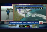
the best chance now is for the coast guard to be able to slip in. it won't happen by air at this time. >> all right. lieutenant general honore, thank you so much for enlightning us. you're going to join us in the next hour in the newsroom. thanks so much. we'll keep updating this story and our prayers go out to those people sitting out in that lifeboat waiting to be rescued. let's now go to battery park city in new york city. that's where john berman is. john, i understand it's getting worse there. >> reporter: i'm standing in water now, carol. just a few minutes ago, the water came up over this seawall right behind me, started lapping in. and now i'm standing in about four inches of water. this is part of the evacuation zone in lower manhattan. you can see why. some 370,000 people evacuated from certain areas in new york city. low lying areas. moved to hotels. moved to their friends' houses, to 76 shelters that have been set up around the city. this is the reason why. they're expecting a storm surge
6:12 am
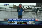
here of some 6 to 11 feet when the storm really starts hitting at high tide tonight. that's about 8:50 tonight. it's high tide right now. a little bit past high tide right now. this is just a small taste of what's to come. frankly, i would have thought we would have started seeing this water recede soon because we're past high tide. but it might be that the storm surge is coming in at a faster rate than the tide is receding. and this is a real risk for certain parts of lower manhattan. if there is serious flooding down here, if we do see that storm surge up to 11 feet, there are concerns that it could flood subway tunnels, maybe get into the electrical grid. mayor michael bloomberg has talked about shutting down two electrical networks here. at least. which could take out power to some 17,000 people at least. of course, many of the businesses, the wall street area, a whole bunch of stuff goes on down here in lower manhattan that takes electricity. that could be at risk. i'll be watching this throughout the day. as i said, high tide is 8:50 tonight.
6:13 am
it's not big, giant waves like you see up and down the east coast. no, it's a slow, steady rise with this water creeping. i can tell you i've been standing here for the last five hours all morning. it's been dry all morning. all of a sudden the water starts coming in. now we're standing in five inches of it. >> it looks miserable there. john berman reporting live from battery park. thanks so much. sani thousands of flights have been canceled across the country. in addition the major new york airports, jfk, laguardia and newark are open. but flights are not going in and out. reagan national, dulles, baltimore international canceled almost all nights. in philadelphia all flights have been shut town. overseas travel affected. 50 flights out of london's heathrow already canceled. if you have to travel and you're not going near the storm check with your airline before heading out the door. with a storm this huge, where you are will ultimately
6:14 am

determine what you see. rain, snow or flooding. he meteorologist jennifer delgado of cnn international is here to break it down for us. the folks in west virginia are going to have a steady downpour today then a blizzard. that's some special kind of hell. >> it's certainly a different type of beast to the storm. we are going to talk more about the snow. looking on the radar right now you can see where the rain is. heavy rainfall coming downright along the peninsula moving to parts of washington, d.c. as we go through about the next hour we'll see a heavier band working through the region. even in some areas along interstate 95 we're hearing reports of flooding issues there. that's why we have some flood warnings popping up there. we're going to continue to follow that. as we move over towards the west in parts of west virginia, down in the southwestern part, we are getting reports of snow coming down. this is the light stuff. here's the good news. say you want to try to get out to the store and get some supplies because there's a
6:15 am
blizzard on the way. the good news is you can still get out now. the bad news is there's a blizzard on the way. it's really going to be firing up as we head later into the evening hours as well as into the overnight hours. i'll give you an idea in the future. we'll take you through till about 2:00, 3:00. next six hours ahead. here's where the heaviest rainfall is going to continue to work in. some very heavier bands in the orange as well as the red. of course, the snow gets working in. but that blizzard warning in place, we're talking in some of these locations across west virginia we're going to see those winds gusting up to 50 miles per hour. then you add in two feet of snow. big time problems there. we'll have more coming up in just a moment. stay with us.
6:16 am

♪ (train horn) vo: wherever our trains go, the economy comes to life. norfolk southern. one line, infinite possibilities.

6:18 am

good morning. i'm carol costello reporting live from d.c. as you can see the rain continues to come down. the worst, of course, is yet to
6:19 am

come. around noontime the rain will really start coming down and the winds will really pick up and then people will really have to hunker down. sandy has the potential to be one of those once in a lifetime storms. the federal emergency management agency is very busy right now from briefing the president to finalizing disaster response plans. craig fugate is fema's administrator. he joins us from fema headquarters in washington. sir, you must be one tired guy this morning. >> morning. >> can you hear me, craig? >> yeah. you're breaking up. >> okay. i'm going to start -- can you hear me better now? >> yes. >> okay. i was starting to feel like i was in that phone commercial, but i'm glad you're here with us and you can hear me. what concerns you the most today? >> that people are, one, looking at some of the initial impacts going, well, it's not that bad and not realizing it isn't here yet. what you're seeing is just the outer bands. people need to stay where they're at if they're safe.
6:20 am
if they haven't evacuated, get somewhere safe. stay off the roads. stay inside. stay safe as the storm comes ashore. >> tell me specifically what fema is doing to help. >> we've been moving folks in teams and equipment since friday. getting stuff in place throughout the region since we don't know exactly who's going to get hit the hardest. and really trying to gear up for what will happen when the storm moves through the area as well as supporting the states as they're getting ready for the initial impacts. >> i know that power outages will be a big concern. the utility companies have tried to get ready. they've created tent cities in states like maryland. they have people who've come in from other states so they can mobilize quickly and get to those who need it the most. you know, as fast as they can. have you communicated at all with the utility companies? >> yes, we have. again, we talk about fema, it's really about the federal teams. the department of energy is our lead. they're working with the utilities, making sure they have what they have.
6:21 am
but i think people need to understand that the weather is going to have a lot to do with how quickly the crews can get to work given the high winds that are going to last for potentially hours, if not over the next couple days. >> we keep hearing that power may be out for several days. up to a week in some places. what are you hearing? >> well, again, we won't know till the storm gets here. that's why we've asked people to prepare for extended power outages. until we actually start seeing how much damage over how large of area and get those initial reports, it's hard to say. given the storm is going to move so slow we do know it will take time for the winds to come down. crews can't work in high winds. although power is going out now, it's getting restored. as conditions worsen the crews will come off the road and won't be able to get back to work till the weather starts to improve. >> do you notice that the effort is more organized on the parts of utilities than, let's say, in previous storms? >> i think every time you have storms, you learn from that.
6:22 am

i think irene gave a lot of opportunities to look at how to do things better in this storm. but i think the difference is this is such a large area that it will take time. particularly since this storm is moving so slow, even though they've done a lot more to get ready, it may still slow down getting those initial power lines back up because of the weather. >> craig fugate, thanks so much for sharing information with us this morning from fema. thanks so much. let's head out to west virginia for just a bit. west virginia governor earl ray tomblin joins us on the phone from charleston, west virginia. >> pleased to be with you, carol. >> is it snowing there yet? >> yes, at our higher elevations, it is. it already has started snowing. it's raining all over the state. of course, we're expecting the high winds to head in here later today. we have deployed our department of highways crews, our national
6:23 am
guard. they're working with our power companies that have been deployed all over the state. like the fema director said, yeah, we're anticipating a lot of power outages and so forth. especially with the high winds and the heavy snow. we're expecting at least two feet of snow, if not more, in our mountain regions. so, wryeah, we're looking at possible flooding in our eastern panhandle over near d.c. and around the rest of the state. so we are preparing. we have asked people to, you know, try to get the emergency supplies in, batteries, food, water. all those things. and so, yeah. we've been gearing up for this for the last couple of days. hopefully we'll not be hit too hard. but we're just sitting and waiting now for the real storm to hit. >> it's hard to imagine that it'll rain continuously for a few hours and the winds will pick up and then you're going to -- then it's all going to turn to snow and get cold. i can't even imagine what that will be like.
6:24 am

can you? >> we're getting a little bit of everything. i guess that's something that maybe the coastal towns are not getting, snow. but here in the higher elevations, we'll be getting that also. especially this time of year, there's still leaves on some of the trees which if it's a heavy snow will have more of a tendency to break trees and bring power lines down. anyhow, our electric companies in west virginia have contacted their sister companies out of state. they have workers coming in. we're just asking people to wherever possible, stay off the roads. let the emergency crews get through. clear the roads so that the power company can get in and do their work as quickly as possible. >> governor tomblin, i know you have a long couple days ahead. thank you so much for joining us this morning. we sure appreciate it. >> thank you. bye-bye. >> bye-bye. we're going to take a quick break. when we come back, more on the
6:25 am

coverage of souperstorm sandy. ♪ ♪ [ male announcer ] don't just reject convention. drown it out. introducing the all-new 2013 lexus ls f sport. an entirely new pursuit.
6:26 am

woman: what do you mean, homeowners insurance doesn't cover floods? [ heart rate increases ] man: a few inches of water caused all this? [ heart rate increases ] woman #2: but i don't even live near the water. what you don't know about flood insurance may shock you -- including the fact that a preferred risk policy starts as low as $129 a year. for an agent, call the number that appears on your screen.

6:28 am

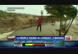
the coast of cape hatteras, north carolina. we've been telling you about that big ship, the hms bounty. it's a rep will lica of a histo ship. there was a crew of 17 onboard. they were trying to escape hurricane sandy but got caught in the storm. 17 people got aboard lifeboats. they were just waiting to be rescued. we have word now the u.s. coast guard was able to rescue 14 of them. but two are missing. whereabouts unknown. there's also a 17th person. the coast guard is not sure whether that 17th person was actually on the ship. they don't know where that person is. so i guess technically three people are missing. we're going to keep you updated on this. we'll have more information in the coming minutes on "cnn newsroom." let's head to virginia beach, virginia, where things are really deteriorating. art cohen from waby joining us now. good morning, art. >> good morning, carol. for the last few days our local
6:29 am

meteorologists have been promising us that this would be the worst of it. and you know what? it's turning out to be that way. to give you a good idea, i'm at 16th street just off of atlantic avenue in virginia beach. to my left is the virginia beach fishing pier. i'll ask photographer walter hildebrand to give you a good look over there. we are seeing some very long seas brushing the top of the pier. there's one there even as we speak. as long as those waves remain underneath the pier we think the pier should be okay. what would be a problem, if the wave height gets even larger, which would only have to be another two or three feet with some of the swells we've seen come in, then the integrity of the pier could be threatened. the other thing we're really watching out here is the tidal surge. water has been coming up to the boardwalk and just a few times washed over the boardwalk. i've lived here in virginia beach all my life. i can tell you, we've only seen that happen a few times. in addition to the tidal flooding along the coast, another big concern here is some of the inland areas of virginia
6:30 am

beach that are fed by the linhaven river and elizabeth river basins. what we're worried about there is a phenomenon called tidal stacking. because of this prolonged wind, remember, this is an event that's been going on for days now. because of the prolonged wind we're having a lot of flooding in those areas inland away from the coast as well. several roads impassable. so as long as this rain and wind continues, that problem is going to persist and probably get worse. that's what we're looking at the most right now, carol. >> art, i couldn't help but notice those two people walking under umbrellas behind you. it's hard to believe anybody would be out in the elements. because not only is it rainy and damp, it's really cold. the kind of cold that kind of seeps through every layer of clothing that you have on. >> yeah. i can tell you about the seeping through every layer of clothing. but i'll tell you something, carol. it's funny that you noticed that. you know something? that's the way coastal residents are. they're drawn to events like this.
6:31 am

despite the miserable conditions, they will come down here to look and see for themselves. you know, we implore them not to do that. we tell them to watch this. but it's -- as i said, what you're seeing right now we haven't seen to this extreme in quite a while. and people just can't resist it. and coastal residents, that's the way we are. >> i think that's the way we are as americans, frankly. we're a curious bunch, aren't we? sometimes to our detriment. >> no doubt about it. >> you got that right. art kohn, thank you from our affiliate wavy in virginia beach, virginia. the national hurricane center just one of many government agencies helping to monitor the superstorm. rick knabb is director of the national hurricane center. he joins us now from miami. rick, tell us what you know about the storm. what's the latest? >> well, the latest is that it is making this turn to the left as it sets its sights on the coastline with a landfall of a
6:32 am
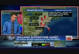
circulation center sometime late tonight, early tomorrow morning. but what we're also seeing is already some very bad weather on the coast in the mid-atlantic states and moving up to the northeast. the rain is falling in some spots in the coastal region here, in the chesapeake bay area area. tropical storm force or gail force winds already occurring in some places. we're seeing initial water rises in many parts of the mid-atlantic, northeastern coastline. a prelude to the storm surge we are expecting to see later tonight and into tomorrow. >> you listen to the weather reports all up and down the east coast and also in the midwest and the meteorologists are saying this is a superstorm. we've never seen anything like this. and i must say that as a viewer, you kind of think, oh, are you exaggerating? so tell us, are these meteorologists exaggerating? >> we are not exaggerating the threat, no. this has many, many hazards that are going to impact a lot of people. and the weather is going to be bad for a long period of time. and even if the center passes
6:33 am
200 or 300 mimes away from you, you could experience very dangerous or even life threatening conditions. storm surge at the coast for which many people have been told to evacuate. i urge people to heed those evacuation instructions. the strong winds at the coast and inland. and heavy rain, the flooding that could occur well inland as well for a few days after landfall. and long after it comes ashore. and even the heavy snow that we're going to see over mount nouz areas of the appalachians, west virginia, for example. this is going to affect a lot of people. and we're not underestimating the threat here. i think it's fwood for people to be hearing that there is a serious storm coming that could affect them individually in ways they've never been affected before. >> rick, thanks so much. rick knabb from the national hurricane center in miami. we're going to take a quick break. we'll be back with much more coverage of hurricane sandy. what's next? he's going to apply testosterone to his underarm.
6:34 am
axiron, the only underarm treatment for low t, can restore testosterone levels back to normal in most men. axiron is not for use in women or anyone younger than 18. axiron can transfer to others through direct contact. women, especially those who are or who may become pregnant, and children should avoid contact where axiron is applied as unexpected signs of puberty in children or changes in body hair or increased acne in women may occur. report these signs and symptoms to your doctor if they occur. tell your doctor about all medical conditions and medications. do not use if you have prostate or breast cancer. serious side effects could include increased risk of prostate cancer; worsening prostate symptoms; decreased sperm count; ankle, feet, or body swelling; enlarged or painful breasts; problems breathing while sleeping; and blood clots in the legs. common side effects include skin redness or irritation where applied, increased red blood cell count, headache, diarrhea, vomiting, and increase in psa. see your doctor, and for a 30-day free trial, go to axiron.com.
6:35 am

anncr: every president inherits few have faced so many. four years later... our enemies have been brought to justice. our heroes are coming home. assembly lines are humming again. there are still challenges to meet. children to educate. a middle class to rebuild. but the last thing we should do is turn back now. president obama: i'm barack obama and... i approve this message.

6:37 am

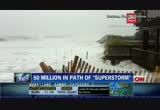
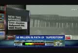
okay. the picture beside me is from affiliate wpvi. that's a look at atlantic city, new jersey. as you know they closed all the casinos in new jersey. hopefully everybody's at home where they're supposed to be hunkering down in preparation for the storm. it's raining, it's nasty there right now. you can see it's a little rough, the surf. the worst is yet to come. we have a couple hours yet and things will really start to deteriorate in new jersey and all along the east coast of the united states and also parts of the midwest. hurricane sandy hours from explodding into the superstorm. most of us have never seen anything like it in our lifetimes. it's already huge with tropical storm force winds spanning the width of nearly 1,000 miles. it's aiming at the heart of the east coast. the most heavily populated corridor in the country. 50 million people already
6:38 am
feeling some of the effects. hundreds of thousands now under evacuation orders. fema predicts damage costs about $3 billion. that's for the wind damage alone. hard to think about all the water damage there's going to be. heavy rains or snow, storm surges and widespread flooding across the region fending on where you live. right now we'll have an update on the hms bounty. 14 sailors have been rescued off the coast of north carolina. two crew members, though, are still missing. their ship the hms bounty started taking on water last night about 160 miles from hurricane sandy. it's off the coast of north carolina. the 80-foot ship was built for the 1962 hollywood movie "mutiny on the bounty." the ship was also used in "pirates of the caribbean." we'll have much more information on the hms bounty in the next hour of "newsroom." let's head back to new jersey, cnn meteorologist rob marciano is in the iconic town of asbury park.
6:39 am

hi, rob. >> reporter: hey, carol. we are on the beach here. asbury park, new jersey, where the sea foam is being sprayed up and the surf continues to pour in. this is an area that should not see this water this high up. obviously these are staircases to what should be perfectly good sandy beaches. instead, we've got surf that continues to hammer away at this structure and at that boardwalk. right around high tide, which is about two to three feet above what we normally see, we've got that. plus the moon is full. that's going for us. one more cycle for high tide, when is that? that's tonight. 8:00, 9:00 p.m. that's when we expect landfall of sandy to make its way about 50 to 100 miles to our south. that puts us right in the area where we should get the strongest amount of storm surge. so this entire area has been
6:40 am
evacuated. that boardwalk which has seen its ebb and flow of economic cycles is zdeserted at the moment. we expect the water to come up and over the boardwalk later on tonight. we have already seen -- i should say i've heard up the road to sandy hook and down the road toward atlantic city where you spoke about the casinos being closed, those areas have reach major flood stages. certainly the waves have been big. anywhere from 15 to 0 to 15 fee. they will increase. some of the buoy rings offshore are outstanding. they'll continue to build as the storm makes its way here. still more than 200 miles offshore, we are getting a tremendous surf action here not to mention the wind and rain that will be increasing throughout the day today. a couple of shelters in place for this county. about 600 people have taken advantage of that. the people that have evacuated
6:41 am

are with friends and family. right now much of jersey is sheltering in place as per the request of governor chris christie yesterday who urged his residents not to take any chances. from what we've seen, they've headed that warning. carol? >> that's a good thing. rob marciano reporting live from asbury park, new jersey. i should explain where i am. i'm in washington, d.c., today. below me is h street. a steady rain has been falling but not a heavy rain. the weird thing about this tropical storm, usually it's really warm during hurricanes. it's cold right now. a damp kind of cold. it kind of goes through every layer of your clothing. i mean, i am freezing right now. it's not even that cold really. probably 45 or 50 degrees. because it's wet and it's damp, it feels so much worse. as you can see, there's light traffic on h street. usually that street would be pretty chock full of cars. federal offices are closed today. a lot of people didn't go to work. of course, schools are closed
6:42 am

all across the region. so people have really heeded warnings. they've stayed at home. and that is only a good thing. san sandy, of course, is expected to have this enormous financial impact, too. alison cottic kosik is at the n stock exchange. that's closed, too, today. >> these estimates about what kind of damage this hurricane could cause, they're all over the map. it's early yet. at this point it's a guess. keep in mind these estimates often end up being much higher after we see the real damage numbers. here are some of the numbers we're seeing so far. what fema says is wind damage alone can cost up to $3 billion. talking about, you know, downed trees from those heavy winds, broken windows. insured losses can go more than $4 billion. that's the hit that insurance companies would take because of claims. another issue with this storm, of course, what kind of damage your homes are going to sustain. meaning flooding and what's known as destruction of property. core logic puts that number at
6:43 am

$88 billion in losses. that number is really high because you see sandy, you see how big this storm is. it's hitting a huge, populated area. lots of houses are in her path. one more area of concern. how much business businesses are going to lose. two days of business. they're going to be shutting their doors, likely wiped out. could be more days than that. also flights canceled. you know, along with local businesses being closed. one economist that we saw, peter morisi, he puts economic losses for this storm as high as $35 billion to $45 billion, carol. >> wow. of course, you're not at the new york stock exchange because, of course, it's closed today. has that ever happened before? >> it has happened before. it is really rare to see weather be the reason for the new york stock exchange to shut down. but it has happened before. in 1985 hurricane gloria hit. that shut down the nyse. before that a snowstorm in 1969. you know, as far as the nyse sees it, it's really all about safety. you know, can these traders get
6:44 am

to the floor? even electronic trading, too. it's not just the nyse. the nasdaq is also closed today. not sure yet about tomorrow. but likely the new york stock exchange will be closed. the storm isn't expected to hit new york city until later this afternoon. so those days could be changed as well. interestingly enough, the futures market, carol, that opened yesterday as normal. it just closed at around 9:15 this morn ing. if you're interested, dow futures are down about 80 points. not a big deal which is good. it shows there's not a lot of panic. some other effects we're seeing in the financial markets, third quarter earnings season. some companies are delaying their earnings reports because of the storm. carol? >> alison kosik reporting live from new york city for us this morning, thanks, alison. we'll be back with much more after this.


6:48 am
all right. kro you're taking a live look at ocean city, maryland. the outer bands of hurricane sandy doing a number on the surf. the lucky thing, it's offseason in ocean city. not many people were in town. most people have obeyed evacuation order. those mandatory evacuation orders went into effect on sunday night. looks pretty empty. we like to see that. sandra endo will give us a more complete update on ocean city, maryland, in the next hour of "newsroom." with us on the phone is petty officer nick kensgemmy with the coast guard. he has an update on the store off the coast of cape hatteras, north carolina. that's where a ship, the hms bounty started taking on water. a crew of 17 were aboard her. they had to abandon ship and get into lifeboats. the u.s. coast guard has to come to the rescue and why don't you take it from there. how did the coast guard manage
6:49 am

to rescue these people in the midst of an oncoming storm? >> well, good morning, carol. it's a pleasure to speak with you this morning. with our rescue crews and air crews, especially with an oncoming storm or hurricane, we're actually minimally staffed at that point. we usually remove our air assets and coast guard assets out of an area so that way they don't sustain any damage. so our search and rescue capabilities are already limited in the middle of a storm. doing a rescue such as this one requires a lot of coordination, recalling certain aircraft and crews, going through enormous amount of safety precautions in order to get our crews out there and to assess the situation in an effective and safe rescue not only for the survivors, but also for our coast guard crews. >> so how did you get the 14 people off those lifeboats? was it be helicopter or did you get them by ship? >> well, early in the morning we sent out an aircraft, an
6:50 am
airplane that located the vessel and established communications with them. they kept -- basically kept an and at approximately 6:30 this morning, we hoisted the first five survivors from the life raft while a second helicopter came in and rescued an additional nine. it was originally reported there were 17 people aboard the ship. and it was later confirmed that there was actually 16 on the boat. and we pulled off 14 and we have a helicopter -- another helicopter en route to actually assist the airplane, there are two people in the water right now. >> you're searching for two people in the water. tell me what that kind of search is like. >> well, the conditions out there on the water are about
6:51 am

40-mile-an-hour winds and 18-foot seas. visibility is about a mile. so they're definitely challenging conditions. but we're throwing our air assets at it. and we are the search and rescue experts. and we're remaining hopeful that we can find these two missing. >> we so appreciate your efforts. this is really heroic because it puts you in a lot of danger, too, as the rescuers in this operation. the other question i had for you, did it surprise you that this ship -- we've lost him. as you heard, it could be a tragic end for some of those people on board the "hms bounty" but we hope not. we'll be right back. ♪
6:52 am

(train horn) vo: wherever our trains go, the economy comes to life. norfolk southern. one line, infinite possibilities. introducing the new 13-inch macbook pro, ♪ with the stunning retina display. ♪ for the pro in all of us.
6:53 am

on gasoline. i am probably going to the gas station about once a month. last time i was at a gas station was about...i would say... two months ago. i very rarely put gas in my chevy volt. i go to the gas station such a small amount that i forget how to put gas in my car. [ male announcer ] and it's not just these owners giving the volt high praise. volt received the j.d. power and associates appeal award two years in a row. ♪
6:54 am

good morning to you. i'm carol costello. hurricane sandy just hours from exploding into a superstorm. it's already fearsome with tropical storm force winds reaching 1,000 miles across. that's how wide the storm is. sandy is now bearing down on the heart of the east coast, the most heavily populated corridor in the country. 50 million people could feel the effects, hundreds of thousands now under evacuation orders. fema predicts damage costs of about $3 billion. and that's just for the wind damage alone. heavy rains and widespread flooding across the region, depending upon where you live. new presidential polls just how tight this race is. the national cnn poll of polls has mitt romney with a 48-46 lead over president obama. in the battleground state of
6:55 am

ohio, a poll of likely voters gives the president a 48% to 45% edge. and a star tribune poll gives the president a three-point advantage. but that's also within the poll's margin of error. super stom sandy is bearing down on election 2012. both campaigns don't want to bother you while you watch the water rise in your basement. but the storm is suspending early voting and the optics of both campaigns, president obama has a quick campaigning and run to country. and mitt romney can't attack the president while he's trying to steady the ship, or can he? with us is lz granderson and will cain. thanks for joining us, guys. >> we just heard the president has decided not only to cancel a florida campaign appearance he had scheduled forred to but also canceling another one scheduled for washington so he can be in
6:56 am

d.c. and keep the ship steady. i suppose that's a great idea, right, lz? >> it's the smart idea. that's what the president of the united states should do in a situation like this. we're talking about a storm that could impact as far west as wisconsin, in terms of winds hitting power lines and causing some outages. it's very important for him to be presidential right now. >> as far as mitt romney goes, he can't attack the president too much. this is a time that the country needs to come together. so, will, what does mitt romney do? >> carol, i think he attempts to be empathetic. he defers to the president and the leadership position the president has and the responsibilities that goes along with that. and he attempts to help -- any private citizen is going to try and help in this situation. politics has to take a backseat. there are political risks. you hate to analyze things politically at a time like this. but president obama has the risk
6:57 am

of handling this the right way and mitt romney takes the risk of looking like that's politicizing anything that goes wrong. >> i think it's important that mitt romney sort of stay in the spotlight because he can't afford for people to forget about him for three days. >> well, you know, he's actually in a real dangerous situation because the more he's in the spotlight regarding this hurricane, the more his appearance during the debate in which he said things like fema having money for fema is immoral and how he wants to privatize relief funds. he doesn't really want that conversation to underbelly or underscore what's going on right now because as people begin to see how important the government is in terms of handling these situations, they're going to be able to propose that to what romney wants to do, take all that money out of fema and put it into the hands of private citizens so people make a profit over whether or not citizens have been put out of their homes
6:58 am

can find shelter. he doesn't want that circling around him at this time. >> will, will that complicate mitt romney's message? is is lz wrong? >> what lz said is untrue. >> look at the tape. >> this isn't a debate. i'm not going to play this game right now. he's talking about a debate from the republican primaries where romney was asked about fema and not privatizing it but handing it over to the states. he did give a non-answer where he endorsed the concept of federalism but never said he would take fema out of the federal realm. >> he doubled down on it this weekend, will. maybe you were out of the loop. but he doubled down on it. >> i don't think will's going to play that game, lz. >> i don't want to play the game either. but i think it is important that we understand what exactly both president candidates want to do
6:59 am

in these situations. and romney has said that he wants to take the money and put it not only in the states but also open it up to privatizing it and the president is showing how important it is that the federal government has a hand in these type of crises. if you were joplin, missouri, talking about nearly $3 billion in damage. a state like missouri cannot handle a $3 billion hit like that. it's not budgeted. and they need the federal government to come in and help in that case. i think you'll see similar situations after this hurricane strategy. some states won't have the money to handle this and will need fema. what romney has suggested is putting that type of funds into the hands of private citizens and letting them try to figure it out for themselves. i think people will be able to see maybe that's not the best solution. >> i have to wrap it up. i'm sorry, will. i have to hit the top of the hour. but thanks for a spirited conversation this morning in the midst of hurricane sandy. will cain, lz granderson, thanks so much. we'll be back. xperienced
7:00 am

extra strength bayer advanced aspirin. in fact, in a recent survey, 95% of people who tried it agreed that it relieved their headache fast. visit fastreliefchallenge.com today for a special trial offer. visit fastreliefchallenge.com anncr: every president inherits few have faced so many. four years later... our enemies have been brought to justice. our heroes are coming home. assembly lines are humming again. there are still challenges to meet. children to educate. a middle class to rebuild. but the last thing we should do is turn back now. president obama: i'm barack obama and... i approve this message.

7:02 am
when the "hms" started taking on water, 90 miles off the coast of cape kottaras, north carolina, they were forced to abandon ship and get into lifeboats. cnn's sandra endo is in ocean city, maryland. you've been talking to the coast guard. most of the crew members have been rescued by helicopter, but two apparently are in the water, sandra. >> reporter: yeah, absolutely. it's pretty horrifying when you hear about the story of those 17 crew members on board that ship. what the big question is right now, carol, is why they were out there.
7:03 am
so that is the big question we're still trying to figure out from the coast guard. but certainly the rescue efforts under way and hopefully they'll be safe and sound soon, carol. >> it's interesting that you say that because the conditions where you are right now probably are pretty reflective of what it was like in north carolina at times. describe the situation right now in ocean city, maryland. >> reporter: well, right now, i can tell you what's happening along this beachfront, i'm standing on the property side, the street side of this protective sand dune. it's taking on water. severe wind gusts at this level. right on the other side of the sand dune is the high tide. you can see the waves crashing even from my vantage point as well. but those waves are fierce. and you can take a look at how much water is pouring over these sand dunes because of those waves. just yesterday, carol, we were able to walk down this path to
7:04 am
the beach. but that beach is gone. and also to give you a expensive of what's going on here, this is the waterfront water here in ocean city. you can see it's taking on water. obviously a lot of the property has been boarded up and protected. but this is certainly not what residents and local authorities want to see right now because they expect conditions only to worsen as hurricane sandy approaches later tonight. but it is high tide. we are seeing a lot of waves come over the sand dune here, flooding this area and also approaching the property line here, carol. >> sandra endo, conditions are deteriorating in ocean city, maryland. i can't imagine what it's like off the coast of north carolina out in the middle of the ocean. in the water waiting to be rescued by the coast guard, going back to the "hms bounty" right now, the ship that tried to escape the hurricane but got caught up in the hurricane. it's a replica of an historic
7:05 am

ship. there it is. a crew of 17 on board. as we said, the u.s. coast guard managed to rescue 14 people. but at last check, two people were in the water. and the coast guard trying to find them. lieutenant general russell ho r honore, what's it like for the u.s. coast guard to find somebody in the water in these conditions? >> it's literally like finding the needle in the haystack. in this condition, technology helped that crew. they were able to communicate with a coast guard 6130 aircraft that flew over them allowing the coast guard to bring in the helicopters to crews those that have been rescued. but this is a very dangerous operation. it's still ongoing. so it's hard to say much more, particularly since two people are still missing, according to
7:06 am

the coast guard's last report. >> i talked with the coast guard. they kept saying that their resources were few, yet they had to go out and conduct this rescue. it puts an enormous strain on the u.s. coast guard to conduct an operation like this, too, especially when they have their forces like out someplace else. >> well, we understand that much of their assets are moved away from the eye of the storm so they can respond. and they only keep what they really need inside the effects of the storm. in the case of their biggest ships that have the capacity to fight that kind of sea, they move them away from the storm, a lot further obviously than this particular hms bounty was. so the rest of that story will still play out. it may be a little early to sound like we're doing any judgment call because in the protocol in search and rescue is to not put blame on the victims.
7:07 am

and we can't do that. so we need to see what happened. the ship captain may have had an equipment malfunction, something to cause him to stray in that water. but at this point in time, they're very luckily, those that have been rescued, you have the best coast guard in the world and they did their job. >> no doubt about that. final word about this, these people were trying to move this ship because they loved it. they just wanted to move to it safety. and now that ship will probably be destroyed. >> more than likely, carol. and thank god for the coast guard to get those that have been rescued. but this is still a big storm. and the worst of it is yet to come, unfortunately. hopefully everybody on land is taking heed. they still have power and televisions on to continue to prepare and stay tfd or have your weather radio available so they can stay informed. >> general honore, we appreciate
7:08 am

it. consider this, a blizzard warning is in effect for parts of west virginia. but to the south, virginia has watched floodwaters rise since yesterday. parts of the state could see as much as a foot of rain and the state's national guard is rolling in as the power outages spread. >> downed power lines from the high wind and probably over 1 million people without power, would be our estimate right now. but fortunately we're prepared. the state, local and federal folks working very well together. and so far, there's no fatalities and people are heeding the mandatory evacuation warnings in certain coastal areas, so it's going okay. >> i almost fell backwards off the balcony here. below me is h street. i'm in washington, d.c. it's been a pretty steady downpour for most of the morning. the rain is not especially heavy just yet.
7:09 am

they're expecting the downpours to be vicious about noon. that's when the winds will pick up. they're expecting 40 to 50-mile-per-hour wind gusts. things will get really nasty because it's pretty cold out here, 45 or 50 degrees. and when it's damp, it feels so much colder. later on this afternoon, i'll be in olde towne alexandria, virginia, an area prone to flooding. some of the predictions this morning are pretty dire in new york city. the projected storm surge could create, quote, a worst case scenario. john berman is in battery park city, a low-lying section of manhattan that's already seeing some flooding. hi, john. >> reporter: hi, carol. this is really an ominous preview of what's to come. a couple of hours ago, the water came up over the seawall right here. it was during high tide at about 8:30. the water rose, came over the wall. and it was much deeper than it is right now.
7:10 am
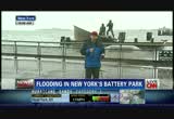
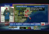
about 6 or 8 inches up here right now. they're expecting a storm surge here of six to 11 feet when the storm really starts hitting the coast later tonight and at high tide, 8:30 p.m. six to 11 feet. if it was flooding this morning, that gives you a sense of just how bad it will be later on. this is the evacuation zone in new york city, lower manhattan, some other areas in the five boroughs. 375,000 people were ordered to leave their homes. michael bloomberg, the mayor here, really wanted those people to get out, for their own safety and also for the safety of emergency workers who might have to go in and rescue them if something goes wrong. the subways are now shut down in the city. there's really no way to get around here. lower manhattan, really a ghost town. although there are some tourists here, people coming to take pictures of the flooding as it came in this morning. i hope they don't come back
7:11 am
tonight. tonight, it could be much, much worse. they're expecting a storm surge anywhere from one to two feet higher than we saw during hurricane irene. during irene, there was minor flooding. but two feet of a higher storm surge could create serious, serious problems in lower manhattan. it could fill the subway system. you could see problems with the electrical system here. not talking about major waves like you're seeing up and down the east coast, not big, crashing, 20-foot waves. it's a slow, steady rise in this water you see behind me. by 8:50, 9:00 tonight, it could be dangerously high. >> john berman reporting live from battery city, low-lying part of manhattan. thanks so much, john. the storm is probably at least 12 hours from landfall. but already new jersey shoreline appears to be in the crosshairs. let's get the latest from asbury
7:12 am
park where rob marciano is. >> reporter: conditions are about the same as when we spoke about an hour ago. the surf continues to pound this area even though we're an hour off of high tide. the water hasn't gone back all that much. that's what we're going to continue to see. even though the tide is going out, the storm surge continues to hold the water and continues to try to push it in. this should all be beach. this should all be sandy coastline right here. but now, it's a foamy brown mess of angry atlantic ocean, thanks to hurricane sandy, which is about 240 miles to our east-southeast and heading in this general direction. we anticipate it to make landfall near atlantic city, near the delmarva. that means we're going to be on the bad side of this storm. we'll continue to get this pounding surf. the last time it was like this was a little over 12 months ago during hurricane irene. but that was at the height of
7:13 am
irene. irene came on shore well to our north. this storm will bring this water up as much as another eight feet, which means the boardwalk will be compromised and the water will be going over the top of that. that's why this area's been evacuated. shelters are open. there's been 600 people that have taken advantage of that. just spoke with an official from the fire department here. a few minor calls into the asbury park fire department with some trees and some power lines down but no widespread damage as of yet. and no rescue operations under way. they certainly hope that trend will continue through the overnight period. in the next 12 hours, that's when things are going to get really hairy. carol? >> rob marciano reporting live from asbury park. thank you, rob, appreciate it. if you want a sense of just how seriously local officials are taking this approaching storm,
7:14 am
consider this -- the new jersey weather service issued this dire warning yesterday for anyone ignoring the evacuation orders. quote, if you are reluctant, think about the rescue/recovery teams who will rescue you if you are injured or recover your remains if you do not survive. and listen to what connecticut's governor said earlier on cnn -- >> we expect today's tide, the one at noon today, could be in the area of the 1992 perfect storm back-up in long island sound. that's going to be a big wake-up call for people if that happens as to what tonight could be, which is far worse. >> getting around during this superstorm is going to be very, very difficult. as you can see, look at how massive that thing is. thousands of flights have already been canceled at airports up and down the northeast. some airports have already shut down operations completely. meteorologist jennifer delgado joins us now. good morning. give us the late zbles good morning, carol. we're going to focus on some of
7:15 am

the travel-related issues with hurricane sandy. we have this information in to us. governor malloy of connecticut has issued a closure of all connecticut state highways by 1:00 p.m. hopefully you've listened to authorities and have your plan under way. to the air, we talk how this is affecting travel. this is our flight explorer. want to point out, this is the northeast, of course you see new york. normally you would see this whole area just lit up in blue. now you're seeing all these planes really flying into illinois, indiana. this is not something you normally see. this is all being rerouted because of hurricane sandy. we know how weather conditions are going to get worse. as we talk about some of the winds, the winds are going to have a big effect here. 37, 43, 37 in new york. of course we saw rob marciano in new jersey. but we're talking a high wind warning in place.
7:16 am

this is in effect for, say, high-profile vehicles, as well as for people who are going to be trying to fly out. we're going to see a lot of cancellations. there have been thousands so far. but look at these winds, spreading over towards the great lakes as well as into areas including parts of detroit. on the radar right now, you do see the rain coming down. we have been hearing reports of flooding along some areas along interstate 95. and that means we are looking at some flood warnings. and more of that flooding is going to continue to get bad as we go through the next couple of hours. you really want to make sure you listen to local authorities and got tennessee supplies that you needed because the worst is still to come. carol? >> thanks, jennifer. we're going to take a quick break. we'll be back.

7:18 am

you're looking live at pictures out of atlantic city, new jersey. you can see that rough surf there. all the casinos are closed. evacuation orders have gone out in this part of new jersey. as you can see from what little bit we can see, people have heeded the warnings. the biggest concern that people have all up and down the east coast and into the midwest are power outages. they are getting ready. and so are the utility companies.
7:19 am
clay anderson which runs the utilities here in the washington, d.c. area is on the phone right now. hi, clay. >> good morning, carol. how are you? >> i'm good. i'm sure you're rather busy this morning. i have heard that utility companies have set up these tent cities and that you have troops in those tent cities ready to go. >> we have our out-of-town crew that is started moving in over the weekend. fortunately we have over 400 men and women that have moved in from states as far away as alabama and louisiana and we're hoping that there will be more to come. the winds are coming through gusting in excess of 40 miles per hour. this is a day that we hunker down, watch the storm and as soon as we get a window, we'll send the trucks out and begin the restoration process. >> as you know, a big election is coming up, clay. and power could go out in some of the polling places. do you have contingency plans?
7:20 am
>> we are working with city and county governments. we've been having meetings over the last several days in the district of columbia as well as montgomery and prince georges counties talking to the county supervises, the mayor here in washington, d.c. so pepco is well aware of the election cycle. hundreds of thousands of people want to place their vote. we have to make sure those polling places will be available. but also with us, we're looking at priorities as far as hospitals, nursing homes, water treatment facilities, with the derecho that went through, we had to work with our sister utilities to make sure that water filtration was trabl in montgomery county. we have a list of priorities. but we understand this is an election year. >> and just the last question for you. you mentioned the derecho, some people were without power for weeks. and they weren't very happy with the utility companies at all. are you better prepared for this storm? >> we're better prepared because we started the communication
7:21 am
process. we told our customers several days ago, all of our customers, that sandy was coming, to expect an extended period of outages, to get an emergency preparation kit. we've been telling them throughout the weekend, this may be a hurricane but it's going to be very cold, very wet and very windy. but pepco will be up to the challenge. >> everyone is hoping so. clay anderson from pepco, thank you so much for taking the time out to talk with us this morning. >> thank you. >> sandy is already impacting election 2012 in a big way. president obama canceled a campaign appearance in orlando to attend business. and he's canceled another campaign appearance later on for wisconsin. early voting just got later in connecticut, maryland, d.c. and virginia. this tweet sent out by the connecticut governor, dan malloy. he said, the deadline to register to vote was tuesday, october 30th. deadline being extended to thursday, november 1st, due to the storm. now, both presidential
7:22 am

candidates are counting on early voters and on absentee ballots. so will sandy be the decider? with me now, democratic strategist maria cardona and republican strategist ron b bonjean. i like tim cain's weather-related advice. they've been asked to uproot campaign signs so they don't become projectiles. but seriously, maria, how will sandy change things? >> there's no question that a storm this big with 50 million people in its path certainly will change things. and both campaigns have to sort of rejigger the way that they are looking at this campaign, including canceling events. we saw the president's canceled all of his events, coming back
7:23 am

to the white house and giving him the ability to look presidential and to exert some leadership over this storm. and mitt romney has also canceled events throughout, which i also think is smart. both campaigns have to be very careful not to look overly political in the coming days when folks are focused on surviving the storm. but, if we are going to look at this from a purely political perspective, i actually think it helps the president because it freezes this race for two to three days. and it gives the president a chance to look presidential. and any coverage that is going to happen, frankly, is going to be the president doing what he needs to do in terms of being the commander in chief of the united states at this time. >> so that presents quite a dilemma for governor romney. what does he do? >> first of all, i have to say i don't think this hurricane helps anyone. i don't think it helps the president because although he is at the white house and he will be commanding the -- commanding
7:24 am

fema, any slip-up, any problem can seriously backfire on him. and what both candidates have to do here is they have to show compassion and they have to connect with what people right now care about. whether or not their power is still going to be on, their basements flooding. they have to stay out of the way but try to show some compassion. that's why you see the president going back to washington. you see mitt romney now urging voters -- urging people to help the red cross. and using his campaign bus to distribute supplies. any way they can connect with voters around the storm but not get in their way i think is smart. >> frankly, maria, if your basement is slowly becoming a waterfield, i'm not sure you're paying attention to either candidate. and the election is sort of out of your mind at the moment. >> yeah. i agree. people's attentions are going to
7:25 am

be on how do they survive this storm, especially, again, 60 million people, 50 million people in the storm's path. all up and down the east coast. so i agree with ron in that both candidates have to make sure that they are in tune with what people are going through to make sure not to politicize this tragedy because we've already seen lives lost from this storm. and a lot more is going to be coming in the coming days. but i do think that it also gives a chance for the media and for folks to look at what these candidates have said in the past in terms of the kinds of services that the government provides in the wake of this kind of storm. and so, for example, in 2011 during the republican primary, mitt romney said flat-out that he thinks that fema should be abolished and should be privatized. really? at this moment in time, i think that's the kind of comment that could come back to haunt somebody like mitt romney.
7:26 am

>> so i have to give ron the last word. ron, button it up for us. >> well, i have to say that i don't think anyone -- most people don't have a positive impression of fema. and i think mitt romney is right on the button. but i don't think anybody cares about that right now. i think people care about whether or not their power is on, whether or not their basements are going to be flooded. and i think if the president gets too far in front of this and something goes wrong, people are going to remember, hey, my power's not out. and the president's talking about fema. i'm not a big fan of fema. that could sway their vote. >> we'll see. ron and maria, thanks so much for the discussion this morning. we appreciate it. we're going live to new york city. governor cuomo is having a news conference. this is in albany, rather. let's listen. >> one of the agencies that assists fema in doing the federal response to disasters, new york state is very well-prepared. our assets and our capabilities only come in after the state has
7:27 am

exceeded their capabilities, which at this time, again, the state looks very well-prepared to do what needs to be done to ride out the effects of this event. so a couple of things that we'd like to emphasize, as we've talked about the surge a little bit in lower manhattan, that's one of the scenarios we think could be problematic. right now, we see the storm at hurricane irene levels. all of you that are familiar with the hurricane irene effects from last year, this event -- we're already at those levels at this point. if you've driven along in the city in manhattan, as the governor has done, you've seen those levels, where they're at. we think there could be some overtopping based on the tidal surge that's going to happen this evening. we're going to be prepared to assist the state and any assistance they have with the specific capabilities and emergency power generation, potentially some pumping and other things that may be
7:28 am

necessary, again, if the capabilities are exceeded. the other potential area we see that could be problematic is the barrier islands in long island, if we have a breach there. we don't see any impacts that could happen that are going to affect life based on that. but i think it would be wise for all to follow the guidance that's been put out by the state in terms of actions to take for evacuation. for post-storm recovery operations, again, that's where we'll work -- the u.s. army corps of engineers will work with fema and quickly try to restore navigational projects and begin efforts to pre-storm levels. we're also very -- we have capabilities and contract mechanisms and assets that are in the area to help with debris removal, infrastructure assessment and there are several other things that would come through from fema if those things are required.
7:29 am

so we're closely in contact with the state at the emergency operations center in albany. and prepared to assist where necessary. thank you. >> thank you very much. first, let me begin by thanking howard glazer, the director of state operations, who's been coordinating this effort and been doing a great job. colonel paul owens, thank you very much, and the army corps of engineers. we're joined by state police superintendent, the captain from the port of the united states coast guard, the deputy administrator of fema and the director of the sport authority and the chairman and ceo of the mta. first, let me report that yesterday we spent the day traveling the state and we are very comfortable with the
7:30 am

preparation that has been done all across the state. we're comfortable with the level of coordination between the state government and the local governments. we went as far as the adirondacks yesterday. and people are prepared. we went through hurricane irene just a little while ago. and the cruel irony, i think the frequency of the exposure has actually assisted us in getting prepared. so i think we've done everything that we need to do. and so far, as you've heard, the storm is as we predicted. there's going to be a lot of rain and there's going to be a lot of wind. and that is precedinpreceding. the question is the extent of the storm surge. it is already high. it's already at irene levels. and the question is going to be, what level does the surge take us to later on this afternoon, later this evening when it's
7:31 am

actually high tide? and that's -- if there's a possible area of concern, that is it. and that's what we are monitoring closely now. as an added precaution today, we are announcing that we are going to close the holland tunnel and the brooklyn battery tunnel, renamed the u.l. carrie tunnel, at 2:00 today. those tunnels are prone to flood. and as a precaution, we're going to be closing those tunnels at 2:00 today. the bridges at this point will remain hope. they close at 60-mile-per-hour winds. weather forecast suggest gusts up to 90 miles per hour. so people should keep an eye on that -- >> we're going to wrap this up right now. it's good to hear that people
7:32 am

seem to be prepared in new york state as they seem to be prepared here in washington, d.c. the worst is yet to come. so be careful. much more on hurricane sandy right after this break. [ woman ] ring. ring. progresso.
7:33 am

i just finished a bowl of your new light chicken pot pie soup and it's so rich and creamy... is it really 100 calories? let me put you on webcan... ...lean roasted chicken... and a creamy broth mmm i can still see you. [ male announcer ] progresso. you gotta taste this soup. mmm i can still see you. the wheels of progress. seems they haven't been moving much lately. but things are starting to turn around because of business people like you. and regions is here to help. with the experience and service to keep things rolling. from business loans to cash management, we want to be your partner moving forward. so switch to regions. and let's get going. together.

7:35 am

checking our top stories now, just minutes ago, new york's governor announced the closing of the holland tunnel, that's in lower manhattan, new jersey, that tunnel will soon close. so keep that in mind. also, connecticut's governor ordered that all state highways closed by 1:00 p.m. eastern as the superstorm sandy bears down on the northeast. boston's transportation system is suspending service today at 2:00 p.m. eastern. hurricane sandy hours from exploding into this superstorm. most of us have never seen anything like this in our lifetime. it's huge. tropical storm winds spanning a width of nearly 1,000 miles. it's aiming at the heart of the east coast, the most heavily populated corridor in the country. 50 million people are already feeling some of the effects.
7:36 am

hundreds of thousands are now under evacuation orders. fema predicts damage costs of about $3 billion. and that's just for the wind damage alone. heavy rains, storm surges, and widespread flooding across the region, depending upon where you are. sandbags are in place, the sump pump is working and you have the flashlights, the batteries and the generator. that means as of now if you live in sandy's path, life is pretty much on hold. alison kosik is in new york. it's eerie. this is h street in washington, d.c. there's virtually no traffic. it's sort of like a ghost down. >> reporter: you should see new york city, the city that never sleeps. i came back from jersey last night covering the hurricane, around midnight. and it was desolate, which is unheard of in manhattan. you were talking about public transportation earlier, boston shutting down its public transportation system. connecticut shutting down its state highways. for the east coast, it really is all about public transportation.
7:37 am

and because all these systems are being shut down, 10 million commuters can't rely on that. talking about here in new york city and washington, d.c. and philadelphia and i'm not even counting amtrak or canceled flights. new york city has the biggest transportation system in the country. millions of riders are affected. the reason why you're seeing these trains and the public transportation being shut is because some of these trains are above ground. they can't run with these high winds. others are below ground and you have the possibility of flooding and then you have trains at street level and downs trees could get on the tracks. so these transportation systems are being proactive, getting the trains and buses into safer areas. they say that will help get things back running faster when the storm passes. carol? >> i know amtrak in the northeast corridor shut down, the metro system here in washington, d.c., shut down. i'm going to ask you a stupid question.
7:38 am

when do you think the trains might be running again? >> reporter: not a stupid question. it's the burning question everyone wants to know. no one is really sure yet. we're still waiting for the storm to actually make landfall. and then of course everybody has to assess the damage before anything gets up and running. what the mta is warning is this is going to be a lengthy process. and we have to all be patient. they inspect every train, every bus, every mile of track before they give the okay to get things running. this is going to be a huge inconvenience for millions of people. but safety is really the big concern here. carol? >> i'm going to share this with you, alison. it's actually snowing here in washington, d.c. i can see the snowflakes coming down, very lightly. but the rain has turned to a sort of weird snow. there it is. that's the u.s. capitol. that's to my right. but you can't really see it because the flakes are really fine and tiny. what a strange hurricane it is. we'll be back with much more after this. tdd#: 1-800-345-2550 when i'm trading, i'm so into it,
7:39 am

tdd#: 1-800-345-2550 hours can go by before i realize tdd#: 1-800-345-2550 that i haven't even looked away from my screen. tdd#: 1-800-345-2550 tdd#: 1-800-345-2550 that kind of focus... tdd#: 1-800-345-2550 that's what i have when i trade. tdd#: 1-800-345-2550 tdd#: 1-800-345-2550 and the streetsmart edge trading platform from charles schwab... tdd#: 1-800-345-2550 ...helps me keep an eye on what's really important to me. tdd#: 1-800-345-2550 it's packed with tools that help me work my strategies, tdd#: 1-800-345-2550 spot patterns and find opportunities more easily. tdd#: 1-800-345-2550 then, when i'm ready... act decisively. tdd#: 1-800-345-2550 i can even access it from the cloud and trade on any computer. tdd#: 1-800-345-2550 with the exact same tools, the exact same way. tdd#: 1-800-345-2550 and the reality is, with schwab mobile, tdd#: 1-800-345-2550 i can focus on trading anyplace, anytime... tdd#: 1-800-345-2550 tdd#: 1-800-345-2550 ...until i choose to focus on something else. tdd#: 1-800-345-2550 trade at schwab for $8.95 a trade.
7:40 am

tdd#: 1-800-345-2550 open an account and trade tdd#: 1-800-345-2550 up to 6 months commission-free online equity trading tdd#: 1-800-345-2550 with a $50,000 deposit. tdd#: 1-800-345-2550 call 1-800-786-7803 tdd#: 1-800-345-2550 and a trading specialist tdd#: 1-800-345-2550 will help you get started today.
7:41 am

♪ it's got something for everyone ♪ ♪ the car of the future many have said ♪ ♪ 'cause at the pump it's miles ahead ♪ ♪ let's hum, hum, hum, hum ♪ let's hum ♪ a prius for everyone ♪ the perfect match, electric and gas ♪ ♪ mile after mile its tank could last ♪ ♪ we made three more for all to use ♪ ♪ big, small, and plug in, it's yours to choose ♪ ♪ and let's hum, hum, hum, hum, let's hum ♪ ♪ a prius for everyone
7:42 am

you're taking a live look at asbury park, new jersey. you can see the surf's really rough there right now. i'm just wondering what the temperature is. here in washington, it's 52 degrees. but yet there are these kind of weird light snowflakes falling. also in nashville, tennessee, it's 37 degrees right now. it's just a strange weather system. and we all get to share. just a short time ago, president barack obama returned to washington. mr. obama left central florida this morning where he was going to attend a campaign rally. just moments ago, he arrived back in d.c. this is andrews air force base. you can see the president getting into his special car
7:43 am

along with secret service agent, making their way back to the white house. these are live pictures, you're saying? no. he's driving toward the white house right now. you can see how much security the president actually needs around him. good thing there's no traffic today. everybody stayed at home. dan lothian is at the white house. good morning, dan. the president decided to come back from florida and canceled another campaign stop as well. >> reporter: that's right. pulling out of florida not only today but also tomorrow, stops in ohio. he was supposed to have another event in virginia tonight. also in wisconsin and colorado, those events the president will not be attending because the white house said it was important for the president to be back here at the white house to monitor the ongoing situation with sandy. in fact, we were told by white house spokesman jay carney that once the president does get here to the white house, he will be convening a meeting in the white house situation room with his
7:44 am

top emergency management officials. some will be coming in via video conference. others will be here in person. this is in addition to some of the briefings that the president has been getting over the weekend, including one yesterday at fema where the president went in person and promised that the federal government would do whatever it takes to help out. >> my message to the governors as well as to the mayors is, anything they need, we will be there. and we're going to cut through red tape. we're not going to get bogged down with lot rules. we want to make sure that we are anticipating and leaning forward into making sure that we've got the best possible response to what is going to be a big and messy system. >> reporter: and that is the message we are told that the president conveyed to a number of governors in those impacted areas, those potentially impacted areas. the president, again, promising that the federal government would not let them down. in addition to that, the president has signed emergency declarations in at least eight
7:45 am

states including rhode island, pennsylvania, new jersey and of course here in the district of columbia. and the big warning from the white house is that everyone out there in those impacted areas should take this seriously. >> absolutely. i'm just curious. i know the president was expected to speak at a campaign rally in florida. why did he make that decision. >> because he was afraid that he wouldn't be able to fly back to d.c. in time because of the storm? >> reporter: yeah, the white house says the main reason the president did pull out is because they wanted him to be back here to not only attend these meetings and these briefings, but to essentially sort of stay on top of the situation. the campaign trail is critical, it's important, certainly with just days to go before the election. but they feel that the best place for the president to be, to really be on top of this storm is right here at the white house. >> dan lothian reporting live, thanks, dan. we're going to take a quick break. we'll be back with much more on hurricane sandy. all energy development comes with some risk,
7:46 am

but proven technologies allow natural gas producers to supply affordable, cleaner energy, while protecting our environment. across america, these technologies protect air - by monitoring air quality and reducing emissions... ...protect water - through conservation and self-contained recycling systems... ... and protect land - by reducing our footprint and respecting wildlife. america's natural gas... domestic, abundant, clean energy to power our lives... that's smarter power today.


7:49 am

as expected, hurricane sandy is picking up steam, a lot of steam. let's head back to atlanta and check in with jennifer delgado. tell us about it. >> hi, carol. we have the new advisory in from the national hurricane center. we do know now that hurricane sandy, the winds have come up. now they are at 90 miles per hour. keep in mind, those are certainly stronger. it's still a strong category 1. it would be a 96 for it to be a category 2. also want to point out to you the pressure. this is one of the lowest pressures recorded for a storm north of cape hatteras, north carolina, and we're talking about 943 millibars. on the satellite imagery you see this saying, it doesn't look that bad. but the problem is the strongest
7:50 am
winds aren't in the center of circulation. this is a wide storm. we're going to be feeling the effects of the hurricane force winds as we go through the next several hours. we're expecting this to make landfall late tonight into early tuesday morning. again, we're talking areas including the possibility of south jersey. now, as we look at this and we track this for you, monday, notice, 90 miles per hour, regardless, we are going to be experiencing the hurricane force winds. and then it's going to be slow moving. as it does move slow, we're talking about the increased threat for flooding and of course we've been going on about this, how the storm surge is going to be the big story, especially for new york. we could see record heights there, six to 11 feet. we'll continue to talk more about storm surge and the update with the national hurricane center coming up in the next hour. carol? >> jennifer, thanks so much. residents are preparing for the worst. that's a good thing. right now, the entire new york city public transportation system, shut down. that means there are no buses
7:51 am

running, no subways, no trains. and in just a couple of minutes ago, the governor of new york said the holland tunnel would also be closing down. other major disruptions through the nation's largest city, schools, the stock market. it's all closed down. soledad o'brien is there. >> reporter: hi, carol. they're also expecting to close the brooklyn battery tunnel. those tunnels are very prone to flooding anyway. in lower manhattan, we've seen some flooding. governor cuomo in his briefing said that we're at irene levels, meaning that the storm surge that we got in irene, we're already there. and we are, as you well know, many hours away from hurricane sandy hitting here. so things are looking a little difficult, if you're just looking at the flooding alone. let me tell you a couple of other worries for people who are in manhattan. i'm in the central park, basically at columbus circle.
7:52 am

those trees over my shoulder, that's central park right now. big concern with these trees. they lost two dozen trees in irene. irene, a much tamer version of a hurricane than what we are going to see. big worry some of those trees could come down in this storm. they spent about $200,000 doing repairs in central park after irene. we expect that number to go much higher. another problem, scaffolding. this scaffolding here is scaffolding around an art project. but there's tons of scaffolding like that all over new york city, big worries about that. and finally take a look at that crane there. mayor bloomberg said the crane structures have been examined and tied down. they should be safe given what we know about the winds. but as you were just reporting, 90 miles an hour now for these winds, there are big concerns about construction sites like that as well. that's it from here in midtown manhattan. back to you, carol. >> thanks, soledad. i swear the wind just picked up in washington, d.c. it's gusting now -- i feel these strong gusts like you normally do during a hurricane as the bands come closer and closer.
7:53 am

soledad talked about the trees. well, the leaves are falling right now. it's fall and they're beautiful but they're falling creating another huge problem for the utility -- actually for those who keep track of the storm sewers. the leaves go in the storm sewers, so does the water. the leaves plug that up and you get flooding in the streets and maybe in homes. that's causing a big problem in that way as well. want to take a quick break. we'll be back with more. jack, you're a little boring. boring. boring. [ jack ] after lauren broke up with me, i went to the citi private pass page and decided to be...not boring. that's how i met marilyn... giada... really good. yes! [ jack ] ...and alicia. ♪ this girl is on fire [ male announcer ] use any citi® card to get the benefits of private pass. more concerts. more events. more experiences. [ jack ] hey, who's boring now? [ male announcer ] get more access with a citi card.
7:54 am

[ crowd cheering, mouse clicks ] [ male announcer ] get more access with a citi card. anncr: every president inherits few have faced so many. four years later... our enemies have been brought to justice. our heroes are coming home. assembly lines are humming again. there are still challenges to meet. children to educate. a middle class to rebuild. but the last thing we should do is turn back now. president obama: i'm barack obama and... i approve this message.

7:56 am

let's head quickly to long island where jason carroll is. there's major flooding there right now. tell us about it, jason. >> reporter: well, just within the past few minutes, carol, we've seen the waters start to rise here. we're in an area called lindenhurst. criss-crossing through this area, you have canals and the water's slowly started to rise smchlt ] down this one particular street, a car tried to make it.
7:57 am

it got stuck. a number of residents here are in the process of deciding should they stay or go as the water continues to rise here. we have anthony here on my left. we have betty lou on the right. anthony, you've been here for about a year. you're going to stay. what would it take you to leave? >> probably my mom and my dad to come and grab me out because they're freaking out. but i'm going to stay. >> reporter: this is an area under a mandatory evacuation. betty lou, you've lived here for 51 years. you say this is already worse than areen was. >> yes, it is. it's worse than areen was. we're just hoping for the best. but it's not as bad as gloria was. >> reporter: you're still debating if you will stay or if you will go. >> correct. my daughter, denise, is saying, you better come out here, mom. >> reporter: as you look at your neighbors across the street -- i'll have you pan over here. you can see some of them watching from their homes, that's what everyone's been
7:58 am
doing. even though the community is under a mandatory evacuation, a lot of folks are coming out here deciding whether they're going to stay, whether they're going to go as the water here in this area of long island continues to rise. carol? >> i just can't imagine the feeling. you're looking at that water on the edge of your property and there's nothing whatsoever you can do to stop it. that must be an awful feeling. we'll check back with jason in just a bit. i'm carol costello. thank you so much for joining me today. "cnn newsroom" continues with ashleigh banfield after a break. if you are one of the millions of men who have used androgel 1%, there's big news. presenting androgel 1.62%. both are used to treat men with low testosterone. androgel 1.62% is from the makers of the number one prescribed testosterone replacement therapy. it raises your testosterone levels, and... is concentrated, so you could use less gel. and with androgel 1.62%,
7:59 am

you can save on your monthly prescription. [ male announcer ] dosing and application sites between these products differ. women and children should avoid contact with application sites. discontinue androgel and call your doctor if you see unexpected signs of early puberty in a child, or, signs in a woman which may include changes in body hair or a large increase in acne, possibly due to accidental exposure. men with breast cancer or who have or might have prostate cancer, and women who are, or may become pregnant or are breast feeding should not use androgel. serious side effects include worsening of an enlarged prostate, possible increased risk of prostate cancer, lower sperm count, swelling of ankles, feet, or body, enlarged or painful breasts, problems breathing during sleep, and blood clots in the legs. tell your doctor about your medical conditions and medications, especially insulin, corticosteroids, or medicines to decrease blood clotting. talk to your doctor today about androgel 1.62% so you can use less gel. log on now to androgeloffer.com and you could pay as little as ten dollars a month for androgel 1.62%. what are you waiting for?
381 Views
IN COLLECTIONS
CNN (San Francisco) Television Archive
  Television Archive News Search Service
  The Chin Grimes TV News Archive
Uploaded by TV Archive on
